Design Review

Overview
This school project explores how to help people find safer, more accessible routes through the city. Through user interviews, affinity mapping, and feature prioritization, I identified key pain points.
The insights highlighted a need to prioritize safety and convenience, particularly for cyclists.
The Limits of Current Navigation Tools
Safety and reassurance are key when travelling, especially in unfamiliar areas, but reliable guidance can be hard to find. While Google Maps is widely used for navigation, there is an opportunity to improve its support for cyclist safety and convenience.
The Opportunity for Safer Navigation
There’s an opportunity to improve Google Maps by creating safer, more accessible travel experiences. A more personalized routing system could help users find paths that better match their needs, supporting more confident and positive journeys, especially for cyclists.


Solutions
Personalized customization options for routes.
Using the customization option, a user can create route preferences tailored to their needs by turning toggles on and off. This straightforward method of customizing a route enables users to enjoy seamless travel with no surprises.
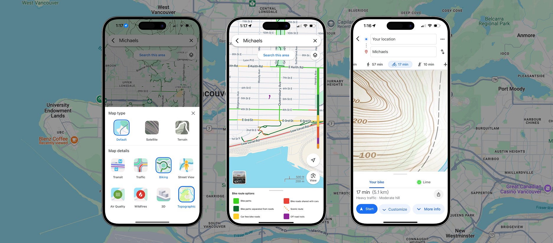
Detailed bike route filter.
A Bike layer that shows different bike route options allows users to visualize where they will bike and what that path might look like. A road bike might not want to go on a gravel trail and choose a different path, whereas a gravel bike might want to stick to the gravel and take a scenic route.
Topographic map layer.
Users can't always tell a hill from flat land. A topographical map will play a significant role in selecting a route, especially when walking or biking. Users can access layers via the layers icon in the top right corner of the screen to locate the Topographic layer under "Map Details". Exploring the topographical map feature enables users to determine the elevation and terrain of routes.
Including local events and activities recombinations.
Locals are more likely to use Google Maps' "latest in the area" page when it is constantly updated with new places and events. Events will enable users to maximize their community experience. Upcoming events allow users to connect with the community and stay informed about local happenings. Users can save events and get notifications and updates about the event.

Helping People Find Their Ideal Path, Wherever They Go.


Reflection
Safety and reassurance are essential when navigating unfamiliar areas, yet reliable guidance isn’t always easy to find. While Google Maps is widely used for navigation and discovery, it still has gaps in supporting safer cycling experiences.
There’s an opportunity to improve this by prioritizing safety and user needs through a more personalized routing system, helping make everyday travel more confident and accessible.